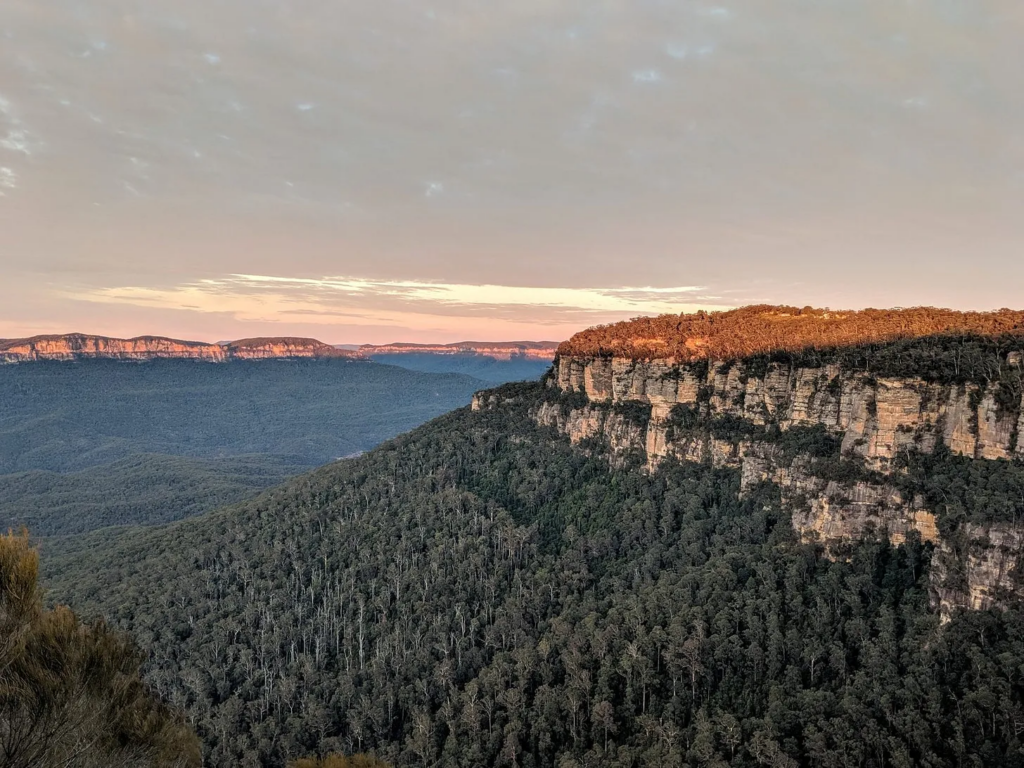
A strenuous but stunning multi-day hike out of Blackheath that encapsulates the “best-of” the Blue Mountains – Victoria Falls, the Blue Gum forest, Acacia Flats and the Govetts Leap falls.
Need To Know
Description: Multi-day-through Hike With Camping
Time: 3 days
Grade: 4.5 out of 5 – Bushwalking experience required; very steep sections
This walk is my favourite overnighter in the Blue Mountains.
It showcases stunning cascades and waterfalls, the tranquil Blue Gum valley and sees you camp the night in some legit bush camp spots with fresh river water for bathing/swimming and drinking. And lots of privacy.
A few words of warning!
1. The track is not well marked down in the valley. Given its remoteness, it is recommended you register your walk at the Blackheath National Parks Office, and grab an emergency beacon from them before heading off.
2. The climb out on the last day is a cracker! You do need hiking (and bush-bashing) experience and considerable fitness.
Hike Details
Distance: 22.6 km
Difficulty: Very hard and requires hiking experience and very good fitness (and knees!).
I suggest getting an emergency beacon – see below for more details.
Map Downloads: Download this great map for a step-by-step guide of the walk.
Bookings
Register your walk with the NPWS office and pick up a Personal Location Beacon (PLB) free of charge.
Front up in person at Govetts Leap Rd Blackheath, which is open 9am-4pm every day. Ph: 02 4787 8877
You can do the same at the Katoomba or Springwood police stations, too. You fill in a trip intention form in advance. You can read more about this here.
Sarah’s Top Three Tips
1. Bring water purifier tablets. The rivers and creeks at camp spots are pretty clean, but they are always recommended.
2. I read Tribe by Sebastian Jungle on this hike. You might like to, too.
3. I hiked this solo, but you would be wise to do it with at least one other, in part due to the remoteness and also because you may have to car shuffle to get back to your car at the end. Read on to see how I managed this technicality on my own.
Getting There
The start of this walk is at the end of Victoria Falls Road, a 5km dirt road not far from Blackheath.
You can organise to be dropped off here and then make your own way home from Blackheath train station, or do a car shuffle with others doing the walk with you (leave one car at the start, the other at the end).
If you are solo, you can hitchhike or catch a cab from Blackheath train station to the start of the walk.
From Wild and Precious
“I followed the trail through the Blue Gum Forest. It’s a glorious winding trail that’s not heavily trodden. As the sun reached the valley, the eucalyptus oil was released and the late-season blossoms drenched the air with honey.
A few hours passed and it occurred to me that I should have intersected with another river by now. I was shoe-horning my way into a dense thicket of tea trees when, suddenly, a young guy appeared behind me. ‘Are you lost?’ He generously realised I was startled and added, ‘I mean, I think I am too, and I live nearby and . . . I’m only eighteen.’ And for good measure, ‘My mum reads your books.’ “
Buy This One Wild and Precious Life
Detailed Itinerary
Day 1 – Victoria Falls to Burra Korain Flat Camping Area
3.1km/1.5 hours
Start from the Victoria Falls Road car park, at the end of a dirt road. You’ll leave your car (or need to be dropped here).
Follow the sign to ‘Grose Valley Lookout’ down the hill. The walk then winds down steps to a lookout. From here, continue straight past the ‘Victoria Falls’ sign, down the hill. You will now wind your way down steps, under rocky outcrops and then steeply zigzag downhill for some time, moving away from the rocky outcrop, into ferns and more grassy undergrowth.
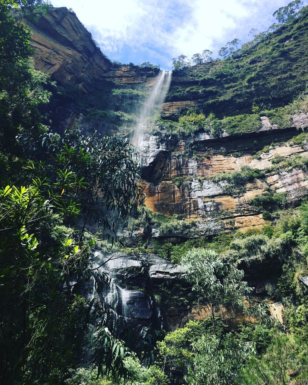
At the intersection veer right following the sign to ‘Cascades’, then continue over the slippery rocks to the bottom of the falls.
From the falls, head over the rocks and downstream (keeping the creek on the right), before turning left into the rainforest vegetation.
At an intersection, follow the sign to ‘Burra Korain Flat’, heading down the stairs. Turn sharp right at a sign marked ‘Top of Falls’ and keep heading down to Victoria Creek. The track then turns left, descending over rocks to the top of Victoria Falls.
You’ll then head upstream, with the water below on the left, up some rock steps and onto a rock-shelf, before turning steeply to the right, up some more slippery rock steps and soon you get to a sign to ‘Burra Korain Flats’ – follow it! The track winds uphill to a railing then down the slippery hillside, descending to an intersection in front of a large, mossy rock.
If you want to check out Victoria Falls, head right following the hillside, keeping the creek below to your left. Retrace your steps to the mossy rock.
At the mossy rock, turn left downhill, keeping the creek to your right. At a clearing, cross the creek and follow the sign to ‘Burra Korain Flat’ downhill, keeping the creek to your left for over 1km.
Day 2 – Burra Korain Flat to Acacia Flat Campground
9.4km/3.5 hours
From the campsite, cross the creek and continue through a grassy area to a clearing with a fireplace and BBQ and a sign to ‘Acacia Flat’.
Continue along the right-hand bank, downstream for 3km. You cross a bunch of creeks until you hit an intersection with a sign pointing back to Burra Korain.
Continue straight. The creek is now below on the left. Soon the track begins to flatten out onto a creek flat area and you’ll hit a clearing with a fireplace on your right. Keep undulating, with the creek to the left, for approximately 2km, to an area where the creek flats broaden. The track passes some more clearings with fireplaces, coming to a sign marked ‘Blue Gum Forest’.
Be aware this section is very tricky to follow. I do suggest grabbing a map from the National Park office if you are not an experienced hiker.
Now follow the sign ‘Camping only at Acacia Flats’, heading downstream. The track tends right, away from the Grose River and towards the hills on the right. The walk then heads downhill and across a small creek and onto the Acacia Flats camping area.
I suggest camping on the river side of the track if you can.
Day 3 – Acacia Flats to Blackheath Station via Govetts Leap
10.1 km/4.5 hours
The next day, head off with the Grose River to the left and pass a pit toilet on the right before climbing up a hill for about 700m. The track turns right and then left to contour for some time before descending to the creek bank, which is on the right. Keep following the creek for 1km along a steep bank until you hit a clearing with a ‘No Camping’ sign. Turn left down to the creek bank at a signposted intersection of Junction Rock.
From Junction Rock, follow the signs to ‘Govetts Leap’ sign. After a few creek crossings, the track continues steeply, upstairs in parts, with the creek, passing waterfalls. Beware: the stairs and hills are steep. Eventually, you’ll hit Govetts leap falls.
Follow the blue signs up and up and up. Eventually, you’ll see a sign for ‘Govetts Leap car park.
At the lookout, you MAY decide to bail and walk from here to Blackheath station. Which would be sad. Because there are still highlights to come…
From Govetts Leap Lookout head down some stairs, keeping the valley to the right. The walk turns right over a bridge, across a viewing area and down steep stairs to Horseshoe Falls Lookout.
Follow the path along the cliff top towards the Horseshoe Falls. After some steep stairs follow the sign to ‘Popes Glen’ keeping the creek below on the right. The track continues to rise before heading back down the hill following the ‘Boyds Beach’ sign (under the bush).
Turn around and follow the rocky steps uphill and then the arrows to ‘Blackheath’. The track continues above the creek (on the right), then crosses a bridge so that the creek is now on the left. The walk crosses a second bridge, then continues for some time up a rocky hill to an intersection below power lines. Keep heading up and cross another bridge, to the intersection with Dell St.
Veer left down Dell St, with the houses to the right. From here it’s an easy walk using Google Maps to Blackheath train station.
Turn It Into An Adventure!
Enjoy a coffee and meal at Anonymous Cafe
Stop off for homemade pickles, bread and locally sourced ingredients at this cute place on the corner of the freeway.
Visit the vintage markets
Check out the Victory Theatre Antiques Centre inside the old period theatre built in 1915, previously home to a cinema, ice-skating rink and peg factory (it’s that big!!). There are 50 old-school dealers spread out over the two floors.
Stay the night and see a movie
Go to Mount Vic Flicks, an adorable, original cinema where you can have tea for a dollar, homemade soup for $4 and watch an independent art-house film for $11.
Grab sourdough in Lawson
On the way up the freeway, stop of at Black Cockatoo bakery to buy organic, slow fermented bready supplies.